Projects, Lessons, Activities (top 2,000 results)
|
Select a resource
Sort by
|
You can study hazards that affect coastal areas. What geological forces cause a tsunami? A tsunami (Japanese for 'harbor wave') is a wave generated by an undersea earthquake, landslip, or volcanic eruption. You can demonstrate what causes a tsunami by simulating an undersea earthquake with a water table. How does the depth of water effect the height of the wave? Do different slopes of bottom change the speed of the wave? Visit the USGS Coastal and Marine Geology Program to find out about…
Read more
How is geology important for our energy resources? Coal, oil, and natural gas are formed by geological processes over millions of years. Certain geological formations can indicate a reservoir of coal, oil, or natural gas. Also, geothermal processes can be used as an energy resource. How are these formations identified? How are the resources extracted? You can use the National Geospatial Program to access, view, and download information from geospatial databases containing a broad spectrum…
Read more
New
Can AI understand human language? In the future, AI could aid in emergency interpretive service in the hospital when translators aren't available. But can current AI algorithms understand non-verbal languages like sign language? In this science project, you will test whether AI can learn sign language gestures or phrases to see if it can be used for interpretation.
Read more
Have you ever noticed an old stone wall and wondered how long it has been there? If there is lichen growing on the wall, the lichen has most likely been living there since the time the wall was made, so if you could figure out how old the lichen is then you could deduce the age of the wall. Geologies use this method, called lichenometry, and other methods to establish dates and temporal sequences as they seek to construct a history from the available evidence. In this geology science project,…
Read more
The same principles of geology that we use to investigate the Earth can also be applied to other planets. Visit the Astrogeology Research Program at the USGS to find out how information about the geology of other planets can be gathered (USGS, 2006). Can you make a map or model of another planet? What minerals are found on other planets? Which planets have similar composition to the earth? What kind of geological forces occur on other planets? Do other planets have earthquakes, landslides…
Read more
What causes landslides? The USGS Landslide Hazards Program conducts research needed to answer major questions related to landslide hazards. Where and when will landslides occur? How big will the landslides be? How fast and how far will they move? What areas will the landslides affect or damage? How frequently do landslides occur in a given locality? Investigate the patterns of landslide occurrence in your area. Are they related to locations, geology, or topography? Are they more frequent…
Read more
New
Lesson Plan
Grade: 6th-9th
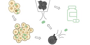
In this lesson plan, students will model the complex biologic manufacturing process. First, they will model the cellular expansion process that occurs in a bioreactor. Then, students will lyse the cells to isolate the proteins from the dyed cell debris. Lastly, they will model the advanced filtration process to purify proteins so they can be used as medicines.
Read more
NGSS Performance Expectations:
Think about mountain ranges, canyons, sand dunes, or any other interesting geological feature you may live near enough to visit. The surface of the Earth is always changing due to a balance of forces both above and below the surface. Below-surface forces cause the Earth's crust to be faulted, folded, tilted, and lifted. Above-surface forces are primarily due to the natural processes of weathering and erosion. Can you show the effects of these forces using scale models, demonstrations,…
Read more
Minerals are sometimes precious, like diamonds. But most minerals are very common, like sodium, which is found in salt. How are minerals found and identified? How are our mineral resources distributed? Visit the USGS Mineral Resource Program to find mineral resources in your state. How are satellite images used to identify potential mineral sources? You can also find out how minerals are identified using spectroscopy. How are potentially harmful minerals, like mercury, dealt with? Visit the…
Read more
Today it is widely accepted that the Earth's crust consists of a series of huge plates that slowly move. The low parts of the plates are beneath the world's oceans, and the high parts of the plates are landmasses. New plate material is generated at deep sea ocean ridges in a process called sea-floor spreading. Material from plates is also recycled at trenches, where dense, oceanic crust dives back (subducts) underneath an adjacent plate towards the upper mantle. Figure 1 shows a map of the…
Read more
Soils are made of particles of different types and sizes. The space between particles is called pore space. Pore space determines the amount of water that a given volume of soil can hold. Porosity is the percentage of the total volume of soil that consists of pore space. Compare the porosity of different types of soil. Which types of soil hold the most water? Can you see this under a microscope?
Read more
What is geomagnetism, and how does it affect the earth? Visit the USGS Geomagnetism program for more information about this invisible force (USGS, 2006). How is the earth's magnetic field patterned? Are the magnetic poles located at the exact North and South Pole? How can the fields be mapped on the Earth's surface? What is declination? Use the mapping tools to study changes in declination patterns over time. (USGS, 2006)
Read more
|